The following paragraph and three figures were adapted from content presented by the International Associatoin of Hydrogeologists: https://regionalgwflow.iah.org/regional-groundwater-flow
Decades of groundwater hydrology research and modeling has demonstrated that flow in the subsurface environment is complex. It consists of shallow and deep flow systems; it is multiscale - a hierarchical system or system of systems. Such flow systems render moving groundwater a universal geologic agent. As such, they are active ubiquitously and simultaneously to great depths in the Earth’s crust. Individual flow systems exert a polarizing effect of natural hydrological, physical, chemical, botanical, thermal, biological, etc., processes and phenomena between their recharge and discharge ends with transitional ones in between. (see Figures 1-3).

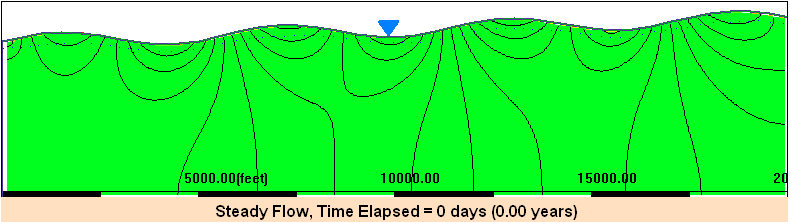
Figure 1: Analytically calculated regional groundwater flow-model for complex topography: regionally sloping and sinusoidally undulating water table (Tóth, 1963).

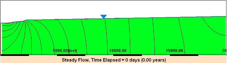
Figure 2: Hydrological effects of the regional gravity flow of groundwater (Toth, 1980).
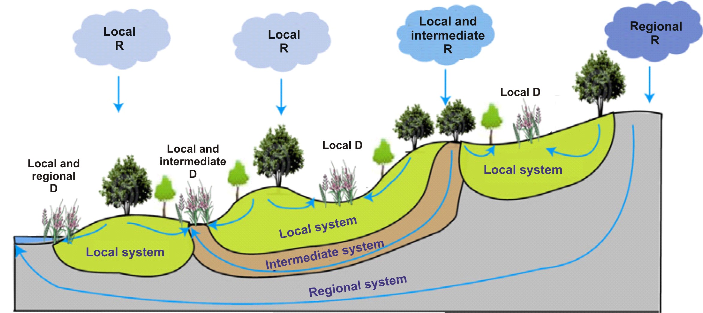 Figure 3: Groundwater and biodiversity conservation (after Brown et al., 2007).
Problem A: Watch the MAGNET videos included below on vertical regional circulation, and answer the following questions:
- Why is that groundwater table is often a "subdued" replica of the land surface at the regional scale?
- Why is that in a complex landscape or hummocky area groundwater flow often exhibits a "multiscale" flow pattern?
- What is a local, intermediate, and regional recharge or discharge area?
- What are the most important factors and/or aquifer properties that control regional vertical circulation patterns?
- Under what conditions, local scale flow systems dominate?
- Under what conditions a regional flow pattern prevails?
- Under what condition multiple scales of flow patterns exist?
- Why is that understanding of regional vertical groundwater circulation patterns is important in sustainable water management, pollution control, siting of waste disposal facilities, and inventories and management of groundwater dependent ecosystems?
Problem B: Develop a MAGNET model that can reproduce the above animations and perform a sensitivity analysis with respect to the following parameters and modeling scenarios, taking advantage of the real-time interactive modeling capabilities
- hydraulic conductivity
- water table configuration (regional slope and scales and magnitude of topographic reliefs)
- aquifer depth
- geological structure:
- A high permeability layer is introduced at depth
- a low permeability layer is introduced at depth
- a high permeability lense underlies the valley
- The region consists of a sequence of thin horizontally bedded aquifers and aquitards.
Write a 2 page memo that summarizes what you learn from your numerical experimentation, paying special attention on different scales of flow systems, discharge areas, recharge areas, and their implications on sustainable water /environmental /ecological resources management.
MAGNET/Modeling Hints:
- Use ‘Synthetic mode’ in MAGNET to create a model domain.
- To create a 2D vertical profile model in Synthetic mode, use a line feature and the 'Equal to Y (e.g., Water Table)' option to delineate the water table surface toward the top of the model domain.
- After your initial simulation, you can "clean up" the display by then making the space above the water table inactive with a zone feature ( 'Flow Properties' tab > 'Zone Type' > 'Inactive' ).
- Use a relatively large NX (e.g., 100) to resolve the water table shape.